


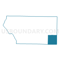
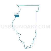
NORTH HENDERSON Voting District, Mercer County, Illinois
About
Outline

Summary
| Unique Area Identifier | 573580 |
| Name | NORTH HENDERSON Voting District |
| County | Mercer County |
| State | Illinois |
| Area (square miles) | 35.00 |
| Land Area (square miles) | 35.00 |
| Water Area (square miles) | 0.00 |
| % of Land Area | 100.00 |
| % of Water Area | 0.00 |
| Latitude of the Internal Point | 41.10764300 |
| Longtitude of the Internal Point | -90.49391190 |
Maps

Graphs
Select a template below for downloading or customizing gragh for NORTH HENDERSON Voting District, Mercer County, Illinois


Neighbors
Neighoring Voting District (by Name) Neighboring Voting District on the Map
- GREENE 1 Voting District, Mercer County, IL
- HENDERSON 2 Voting District, Knox County, IL
- KELLY Voting District, Warren County, IL
- OXFORD Voting District, Henry County, IL
- RIO Voting District, Knox County, IL
- RIVOLI 2 Voting District, Mercer County, IL
- SPRING GROVE-ALEXIS Voting District, Warren County, IL
- SUEZ 2 Voting District, Mercer County, IL
Top 10 Neighboring County Subdivision (by Population) Neighboring County Subdivision on the Map
- Greene township, Mercer County, IL (1,640)
- Oxford township, Henry County, IL (1,213)
- Rivoli township, Mercer County, IL (1,142)
- Henderson township, Knox County, IL (1,135)
- Spring Grove township, Warren County, IL (1,013)
- Suez township, Mercer County, IL (595)
- Rio township, Knox County, IL (518)
- North Henderson township, Mercer County, IL (421)
- Kelly township, Warren County, IL (346)
Top 10 Neighboring Place (by Population) Neighboring Place on the Map
Top 10 Neighboring Unified School District (by Population) Neighboring Unified School District on the Map
- Galesburg Community Unit School District 205, IL (34,926)
- Sherrard Community Unit School District 200, IL (9,307)
- United Community School District 304, IL (6,125)
- ROWVA Community Unit School District 208, IL (3,879)
- Alwood Community Unit School District 225, IL (2,398)
Top 10 Neighboring State Legislative District Lower Chamber (by Population) Neighboring State Legislative District Lower Chamber on the Map
- State House District 72, IL (101,862)
- State House District 74, IL (100,949)
- State House District 94, IL (100,005)
Top 10 Neighboring State Legislative District Upper Chamber (by Population) Neighboring State Legislative District Upper Chamber on the Map
- State Senate District 37, IL (218,476)
- State Senate District 36, IL (206,729)
- State Senate District 47, IL (203,948)
Top 10 Neighboring 111th Congressional District (by Population) Neighboring 111th Congressional District on the Map
Top 10 Neighboring Census Tract (by Population) Neighboring Census Tract on the Map
- Census Tract 404, Mercer County, IL (4,183)
- Census Tract 1, Knox County, IL (3,138)
- Census Tract 312, Henry County, IL (3,014)
- Census Tract 2, Knox County, IL (2,926)
- Census Tract 8703, Warren County, IL (2,706)
Top 10 Neighboring 5-Digit ZIP Code Tabulation Area (by Population) Neighboring 5-Digit ZIP Code Tabulation Area on the Map
- 61401, IL (34,788)
- 61486, IL (1,552)
- 61412, IL (1,321)
- 61465, IL (1,213)
- 61413, IL (1,075)
- 61472, IL (648)
- 61466, IL (342)